Coordinates - GPS Formatter 4.9.6
Free Version
Publisher Description
Coordinates - GPS Formatter - Simple and easy to use app for determining coordinates of various formats.
Simple and easy-to-use app for determining coordinates in various formats.
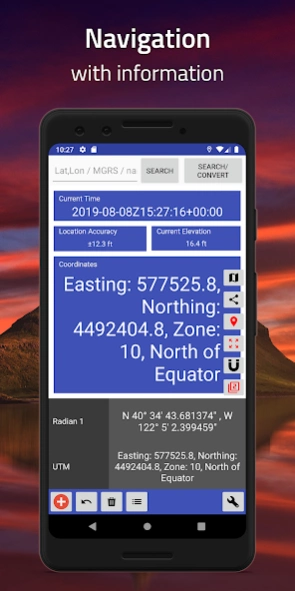
## Simple Design ##
Just locate your position in the center of the screen (where the gray line intersects), and the result will appear instantly, or you can manually enter a value! It's also possible to import locations from the clipboard. Search for locations by place name, city, state, or country.
## Supports Many Coordinate Formats ##
This app doesn't just display plain longitude or latitude data; it also supports various coordinate formats and systems, including the Universal Transverse Mercator coordinate system (UTM), Military Grid Reference System (MGRS), and World Geographic Reference System (Georef).
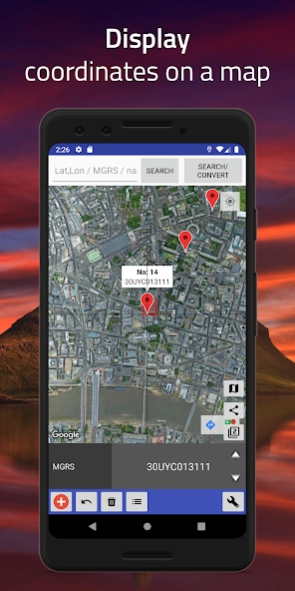
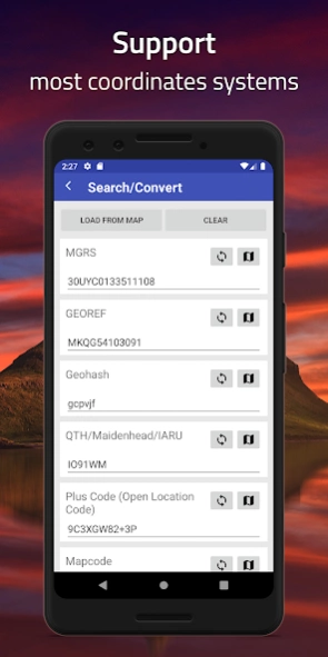
## Search, Convert, and Transform ##
Convert between multiple coordinate formats, import coordinate values from photos, or simply select a location on a map for conversion.
## Tracking and Navigation ##
Pin your location on the map and start navigation. Compass, Bearing, and Distance are updated in real time. Large coordinate readout for field use.
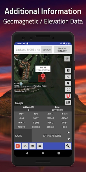
## World Magnetic Model Calculator ##
Calculate values for the geomagnetic field, such as magnetic declinations, intensity, magnetic grid variation, and more. This app uses the World Magnetic Model (WMM) 2015 and/or WMM 2015v2.
Supported Format:
(WGS84) Latitude and Longitude in Decimal Degrees
(WGS84) Latitude and Longitude in Degrees and Decimal Minutes
(WGS84) Latitude and Longitude in Degrees, Minutes, and Seconds
Standard UTM
NATO UTM
Military grid reference system (MGRS)
World Geographic Reference System (Georef)
QTH Locator (Grid Square) / Maidenhead Grid Square
(WGS84) World Mercator
(WGS84) Pseudo-World Mercator / Web Mercator
Geohash
Global Area Reference System (GARS)
ISO 6709
Natural Area Code
OS National Grid Reference [BNG]
OSGB36
what3words
Irish Grid Reference / Coordinates
Mapcode
Plus Code (Open Location Code)
Dutch Grid
Indian Kalianpur 1975
Open Postcode
Geohash-36
Guatemala GTM
QND95 / Qatar National Grid
EPSG:4240 / Indian 1975
EPSG:2157 / IRENET95 / Irish Transverse Mercator
SR-ORG:7392 / KOSOVAREF01
EPSG:23700 / HD72 / EOV
Kertau (RSO) / RSO Malaya (m)
Timbalai 1948 / RSO Borneo (m)
Estonian 1997
EPSG:3059 / LKS92 / Latvia TM
NZGD49 / NZMG
EPSG:2193 / NZGD2000 / NZTM
EPSG:21781 / Swiss CH1903 / LV03
EPSG:2056 / Swiss CH1903+ / LV95
EPSG:2100 / GGRS87 / Greek Grid
EPSG:3035 / ETRS89-extended / LAEA Europe
NTF (Paris) / Lambert zone II
Arc 1950
Albanian 1987 / Gauss-Kruger zone 4
American Samoa 1962 / American Samoa Lambert
CR05 / CRTM05
HTRS96 / Croatia
S-JTSK / Krovak
Hong Kong 1980 Grid System
ISN2004 / Lambert 2004
ED50 / Iraq National Grid
Karbala 1979 / Iraq National Grid
Israel 1993 / Israeli TM Grid
JAD2001 / Jamaica Metric Grid
ED50 / Jordan TM
KOC Lambert
Deir ez Zor / Levant Stereographic
Deir ez Zor / Syria Lambert
LGD2006 / Libya TM
LKS94 / Lithuania TM
Luxembourg 1930 / Gauss
Arc 1950 / UTM zone 36S
Tananarive (Paris) / Laborde Grid approximation
MOLDREF99 / Moldova TM
Montserrat 1958 / British West Indies Grid
Amersfoort / RD New -- Netherlands - Holland - Dutch
RGNC91-93 / Lambert New Caledonia
NZGD2000 / NZCS2000
Palestine 1923 / Palestine Belt
Panama-Colon 1911
Pitcairn 2006 / Pitcairn TM 2006
ETRS89 / Poland CS92
ETRS89 / Portugal TM06
NAD83(NSRS2007) / Puerto Rico and Virgin Is.
Qatar 1974 / Qatar National Grid
Pulkovo 1942(58) / Stereo70
British West Indies Grid
RGSPM06 / UTM zone 21N
Ain el Abd / Aramco Lambert
Yoff / UTM zone 28N
SVY21 / Singapore TM
Slovenia 1996 / Slovene National Grid
Korea 2000 / Unified CS
Madrid 1870 (Madrid) / Spain
Kandawala / Sri Lanka Grid
SLD99 / Sri Lanka Grid 1999
Zanderij / UTM zone 21N
Hu Tzu Shan 1950 / UTM zone 51N
Lome / UTM zone 31N
TGD2005 / Tonga Map Grid
US National Atlas Equal Area
WGS 84 / Antarctic Polar Stereographic
WGS 84 / NSIDC Sea Ice Polar Stereographic North
Pulkovo 1942 / SK42 / CK-42
PZ-90 / ПЗ-90
NAD27
H3
GDM2000
And more
More formats and features will regularly added in the future.
About Coordinates - GPS Formatter
Coordinates - GPS Formatter is a free app for Android published in the Geography list of apps, part of Education.
The company that develops Coordinates - GPS Formatter is Mapnitude Co., Ltd.. The latest version released by its developer is 4.9.6.
To install Coordinates - GPS Formatter on your Android device, just click the green Continue To App button above to start the installation process. The app is listed on our website since 2024-01-10 and was downloaded 19 times. We have already checked if the download link is safe, however for your own protection we recommend that you scan the downloaded app with your antivirus. Your antivirus may detect the Coordinates - GPS Formatter as malware as malware if the download link to com.myice92.coordinates is broken.
How to install Coordinates - GPS Formatter on your Android device:
- Click on the Continue To App button on our website. This will redirect you to Google Play.
- Once the Coordinates - GPS Formatter is shown in the Google Play listing of your Android device, you can start its download and installation. Tap on the Install button located below the search bar and to the right of the app icon.
- A pop-up window with the permissions required by Coordinates - GPS Formatter will be shown. Click on Accept to continue the process.
- Coordinates - GPS Formatter will be downloaded onto your device, displaying a progress. Once the download completes, the installation will start and you'll get a notification after the installation is finished.
